Taipei geography
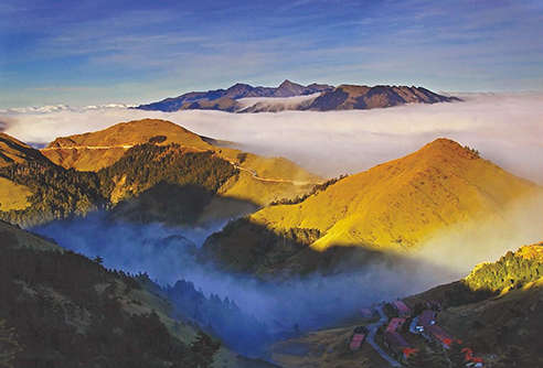
Afternoon in the hills near Taipei
Taiwan has many name: Chung-hua Min-kuo; Formosa; Republic of China; T’ai-wan but they all refer to a series of islands off the coast of China. Taiwan itself is located north of the Philippines and to the south of Japan. The Pacific Ocean lies to the east of Taiwan while the East China Sea surrounds the north and the South China Sea to the south. The Taiwan Strait borders the western side of Taiwan. Taiwan has more than twenty rivers the largest being the Jhoushuei River (187 kilometers in length), the Gaoping River (171 kilometers in length), and the Danshuei River (159 kilometers in length). Taiwan has a subtropical and tropical climate. Taipei itself is located on the northern tip of the main island surrounded by New Taipei City. It has three main topographical features: hills, basins, and volcanoes.
Taiwan’s position in the Western Pacific region affects its climate. Due to the subtropical and tropical climate it is warm in the summers and mild winters. Taiwan receives 102 inches of rain per year, which allows for rice harvests. Sometimes there are up to two or three rice harvests per year. Other types of vegetation that can be found in Taiwan are camphor laurel, cedars, junipers, and maples. However Taiwan receives its share of natural disasters such as typhoons and earthquakes. The Toraji typhoon claimed 214 dead and missing lives. The Chi-Chi earthquake claimed a total of 2,434 lives and injured over 12,000 people. Some of these natural disasters are due to climate change in Taiwan. A severe increase in rainfall and sea level has resulted in the loss of crops and lives. A drastic increase in temperature has reached levels of almost twice the global average. The severity in climate change can leave Taiwan in devastating loss.
Taipei is covered in hills, volcanoes, and basins. The volcanoes located in Taipei are mostly cone and bell andesite volcanoes. The volcanoes mostly belong to the Datun Volcano Cluster. The volcanoes in this cluster are mostly stable with the exception of post-volcanic activity. Taipei’s last eruption was close to 5,500 years ago but this eruption is considered insignificant. Taipei’s hills are mostly in the southeast and are mostly formed sedimentary rock. These hills are part of Taiwan’s western fault mountain. The two major regions of hills are the Nangang Hills and the Heihu Hills, separated by the Keelung River. Taipei houses structural basins, which contain a series of faults, formed along the bottom of the basin. A specific set of faults resembles an isosceles triangle. These basins are near the region of the Keelung, Tamsui, and Xindin Rivers, and near the Guandu Pass.
Considered to be one of Taiwan’s most distinguished geographical features is the Central Mountain Range or the Changyang Shanmo. Another distinguished feature is Taiwan’s highest peak (at 12,959 feet) the Jade Mountain or Yu Shan. Taiwan has many valleys due to the hills, gorges, and rainfall. Western and inland Taiwan is where you will find most of Taiwan’s population and farms. Taiwan's overall geography affects its history and culture as well as its environmental issues.
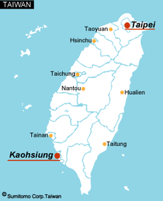
Taipei on a map of Taiwan.
